Thursday, November 6, 2014

Final Post

Friday, November 7

This will be our final post for this trip.  Thanks for coming along with us.  Writing the posts and selecting the pictures has been a lot of fun and as much a part of the trip as the other experiences we enjoyed.  We had you, our friends and family, in mind with every post and picture, trying to imagine how best to keep you coming back for more.  We hope you enjoyed it.  We had approximately 40 views per post on average for the entire time.  I would never have guessed that!

We were gone 51 days, drove 8700 miles and burned 912 gallons of gas.  The steepest grades we climbed and descended were 8%.  We visited 12 states and 24 National Parks, Monuments, Historical Sites and Battlefields.  We camped in all kinds of campgrounds.  The National Parks and National Forest campgrounds had no hookups at all but tended to cost the least.  We stayed in state parks in Oklahoma and Oregon with full hookups and they cost approximately $20 per night.  We stayed in full service commercial RV parks 17 nights at a cost of about $35 per night although the one in Estes Park, Colorado was outrageous at $59 per night.  We stayed at KOAs twice and they were consistently nice with all amenities including laundry and were priced about the same as the others.  We stayed in an RV park outside Petrified Forest for free.  The average campground cost for all 51 nights was $18.85.

We can’t pick a single favorite park or site because each has its own spectacular features very different from the others.  But our top three would be Yellowstone, Death Valley and the Redwoods.  (Crater Lake is probably No. 4). There were some other National Parks that were on our initial list but we set them aside for another time.  Those were all the ones in Utah – Zion, Bryce Canyon, Arches, Canyonlands and Natural Bridges.  We also did not visit Kings Canyon and Sequoia National Parks in California because we made a mistake by going south on the east side of the Sierra Nevada Range and there were no east entrances to those parks.  There was an east entrance into Yosemite though.  But 51 days was plenty and we were ready to come home so we scratched those for now.

I have to say that California has more than its fair share of National Parks at seven by our map.  Six were on our list even though we only visited four.  California, with ocean, mountains and desert has something for everyone.  They have it all.  They also have the highest gas prices.  The most we paid was $4.69 in Lee Vining but that wasn’t typical.  Gas prices are high throughout the west but somewhat more in California.  Groceries there were also high.

People were nice to us everywhere we went and were generally helpful and open to conversation if you wanted to initiate it.   People in parks and especially with RVs all want to know where you’re from and where you’ve been.  And they want to tell you where they’ve been.  Park Service rangers and staff were great and ready to help and answer all questions.  But I think the time of year we visited mattered too because there were no crowds and sometimes the staff just wasn’t very busy.  Yosemite might have been the exception.  We were there on a Saturday.

We learned some things.  We learned that this is a big country and there is a lot to see and love about it.  We also learned that, as big as it is, wherever you go, people have been there before already. We learned that every place we went has a history of native peoples having already lived there for hundreds of years – including Death Valley.

We learned that a National Park is created through an act of Congress and a National Monument is created through an executive order of the President.  Both, and the National Battlefields and Historic Sites, which include both natural and cultural treasures, are administered by the National Park Service.


We learned from our visits of the Indian Battlefields and Missions that our American history education is Eurocentric.   The winners in human conflict write the history.  But there is an Indian side to the stories behind the battles and we’re glad it’s being told too.

Now, we have a few repairs to make to the trailer before any more trips.  The fan motor in the space heater squeals.  I couldn’t fix it on the trip.  We broke a suspension spring bolt but it didn’t come out all the way.  The washer and nut are gone but the bolt is still in place.  I just checked it every day and hammered it back in as it needed it.  The roof vent cover for the bathroom broke loose one night in a screaming wind.  It’s tied down with some twine for now.  The TV antenna crank handle broke but there wasn’t any TV reception anyway so no loss there.  All in all, we fared OK.  It was a great experience for us and I hope it was in a proxy kind of way for you too.


End of Blog.

Washita Battlefield National Historical Site

Our last stop was at the Washita Battlefield National Historical Site at Cheyenne, Ok.  We drove from Santa Rosa, NM to Cheyenne and got there about 3:30 and spent a little time in the visitor center and watched the film.  Then the next morning we walked the trail of the battlefield and took along the trail guide.

The Battle of the Washita is a significant encounter of many between the U.S. Army and the Plains Indians.  It involved Col. George Custer and the 7th Cavalry against Chief Black Kettle and the Southern Cheyenne and Arapahoes that took place November 27, 1868, eight years before the battle of  Little Bighorn.  The details of it are gruesome and best left for the reader to research on his own.

One fact about it that I found interesting was about Magpie.  As a Cheyenne boy, he was being overrun at Washita by a soldier on horseback and managed to turn and shoot the soldier before he was killed.  He lived to fight the 7th Cavalry again at Little Bighorn and lived through that one, too.  There is a picture in the Washita visitor center of him and his wife and two daughters taken in 1890.  I wonder if there were any interviews with him as there were with some other Indians.  If anybody can find out about that I'd sure like to know.

We're home now.  We got here at 5:00 Wednesday, the 5th.   It was a great trip.  I'll have one more post to wrap up the whole adventure.


Wednesday, November 5, 2014

Petrified Forest and Painted Desert

Monday, November 3

We're nearing the end of  the trip.

We drove from Dolan Springs, Az to the Petrified Forest National Park near Holbrook, Az on Saturday.  I don't know how far that was in miles but  it was a day's drive.  We had no  idea where we would camp but we followed the signs to the park.  We knew we couldn't camp inside the park but, just as we arrived, a campsite appeared like an apparition.  There was free camping just outside the park gates beside an Indian Rock shop.  Never one to turn  down free camping, we set up and got a good nights rest and toured around on Sunday.  It was very windy and cold that day.  But since you've come a long way to see things you  just go out into it and pretend it's sunny and warm.

Worldwide, petrified wood isn't  rare.  But this place, the National  Park, is the largest concentration of petrified wood in the world.  It's created by forces of  geology acting over eons of time.  The trees here are tropical  trees from when the land that is now Arizona was in a tropical latitude.  The trees died and were buried, minerals were deposited in wood celluloid, heat and pressure were exerted and then it was all displaced upward where it laid  it on top of the ground for us all to see.  Not much became of it until it was discovered by explorers and a lot has been carried  off  over the years since. It is illegal to take anything out of the protected area now but people still  try to do it.

The Petrified Forest and Painted Desert are together in the same National Park.  You drive north through the park then cross Interstate 40 into the Painted Desert.  Only a small part the Painted Desert is in the park.

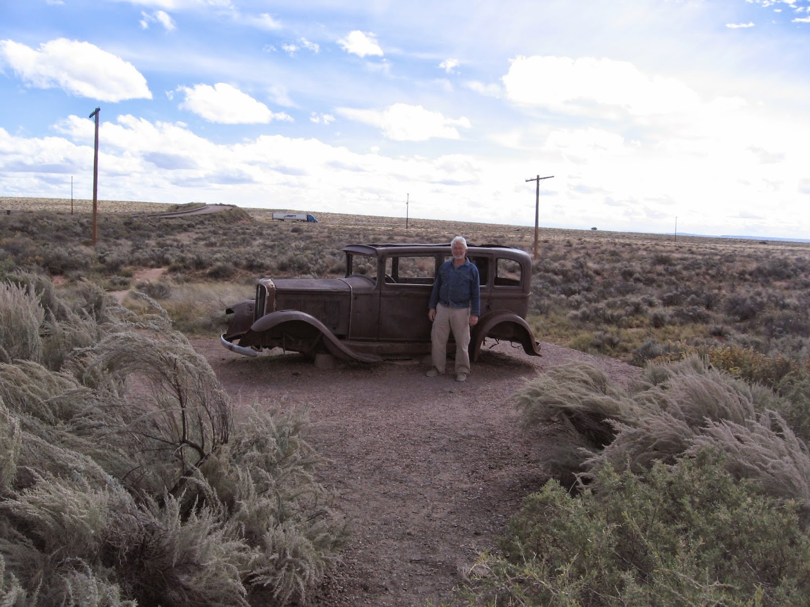
After crossing I-40 we came across this old rusted Studebaker which is in the park and is there to commemorate Route 66 across America.  It sits where Old Route 66 was at that point.  It is just a photo op for people to enjoy.

Today, Monday, we drove to Albequerque, NM to visit the Petroglyph National Monument.  We were only there for a couple of hours, took the short hike around the rock markings and then left.  The petroglyphs, ancient Pueblo etchings in the  rocks, are 1000 to 1200 years old.  The meanings are not clear in all cases.  Some figures of animals, people and objects are obvious but others are not.  Pueblo Indians consider this the sacred ground of  their ancestors.

We spent Monday night in an RV park  in Santa Rosa, NM.  Tomorrow, we head east with one more stop to make - The Washita River Battlefield National Historic Site in Cheyenne,  Ok.


Petrified log, some are more colorful than others.


Nearly a whole petrified tree with root ball.


Petrified log with amazing colors.  Some of the whites are actually clear agate.


Placard pertains to next picture of Agate Bridge


Petrified log bridge - note the concrete support built in 1917.  Also read picture placard above.


Old rusted Studebaker on Historic Route 66

Painted Desert


Pueblo Petroglyph at Petroglyph National Monument near Albequerque.  This is one of thousands.  The etchings are very old.

Tuesday, November 4, 2014

Grand Canyon West

Friday, October 31.

We wanted to go onto the skywalk bridge at the Grand Canyon so we did.  As you may know, it is a glass floor that goes out onto the Grand Canyon with  about a 4000 foot clear space below.  You walk on the glass. They won't let you take cameras or any personal effects out onto the skywalk with  you.  You also have to put on  paper booties to protect the glass.  The only picture I have of the skywalk is from a distance.
I will say that the skywalk gave me an insecure feeling.  I thought the glass might crack.  Of course, that's ridiculous - never-the-less, I had that nervous feeling.  You just might too but I know it's safe.

Then we got really crazy and decided to do the package deal and include the helicopter ride down into the canyon.  It took us through the canyon and over the river then dropped us off at a point where we had to walk down to a boat.  The boat took us out onto the Colorado River for about a 20 minute sightseeing cruise.  Then the whirlybird picked us up and took us back to the starting point.  It was an incredible way to see an incredible sight, what a thrill!

You get to Grand Canyon West by going north on Pierce  Ferry  Road off of U.S. 93 just north of Kingman, Az.  It is on Hualapai Indian land and is pretty much an all day visit, especially if you do the helicopter and skywalk.  Buses make rounds from the main site to several other view points, each one of  them offering a different view of the canyon from the rim.  It is not the National Park part of the Grand Canyon.

We stayed in a little RV park in Dolan Springs, Az for two nights.  We had no idea where we might stay or what we would be doing at the Skywalk so we stopped in for information.  We got the information and the site with hookups.  The RV site certainly wasn't anything special but the people were very friendly and were genuinely glad to have us as guests and so it worked out fine.  We were the only ones and the only RV in the place.  Dolan Springs is on Pierce Ferry Road.  From Dolan Springs it was about a 45 mile drive to the Skywalk through a Joshua Tree forest.  We both love those Joshua Trees, never have seen anything quite like them.


The Helicopter


View from Helicopter


Linda in  Helicopter


View from Helicopter


Boat ride on Colorado River


On the boat in the Colorado River


Deadly dropoff in Grand Canyon


The Skywalk


Another Deadly dropoff


Down Grand Canyon from a Hualapai lookout


A forest of Joshua Trees


Closeup of a Joshua Tree

Monday, November 3, 2014

Death Valley 3

Our last day in Death Valley was driving to overlooks and short hiking trails to some of the main features.
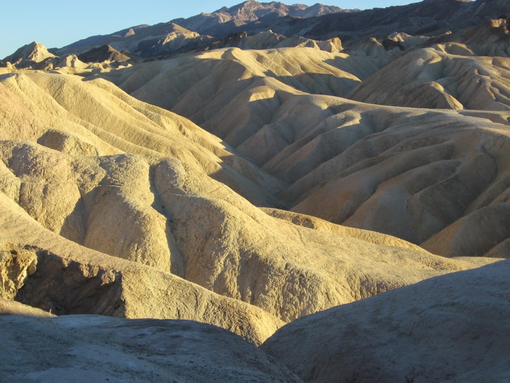
Artists Pallette is a colorful drive through the canyon with pullouts for pictures.  As you can figure, it's the different minerals in the eroded areas that give it its color.

The Devil's Golf Course is a large area of boulder sized chunks of salt.  The salt formations even come to sharp points that can cut or puncture you so the signs warn to stay away.  The "golf ball" is a salt formation.  \

The overlook is named "Dante's View".  The picture doesn't capture it.  It is a panorama of Death Valley as far as you can see.  You can see the salt at Badwater Basin, the devil's golf course, the campground and the paved road for miles.

We enjoyed every one of the "must see" spots at Death Valley.  There are also hiking trails to other features but they warn that it can be dangerous so take lots of water (especially in the summer) and take park maps, do not rely on your electronic gadgetry.  If you should get lost back in a canyon in the hotter times of the year then you will most likely die.

We left Death Valley Thursday morning, October 30, for Grand Canyon West on the Hualapai Reservation.  We're going to helicopter down into the canyon.


Artists Pallette


A piece of salt from Badwater Basin


Badwater Basin, the lowest point in North America


See the placard below.  This is the "golf ball" in The Devil's Golf Course


Devil's Golf Course


Overlooking Death Valley from 5000 foot peak


Me and an odd shaped Volcanic Rock, looks like E.T.


20 Mule Team Canyon where they mined Borax


Pool at the famous Furnace Creek Inn

Sunday, November 2, 2014

Scotty's Castle

Tuesday, October 28.

Nearly all of the national parks we visited are huge.  It is often a hundred miles round trip to see a feature in the park.  And it is almost always worth the drive.  It is the same with Death Valley.  The paved roads go to or near the most popular things to see.  It was over 100 miles round trip from our campsite at Furnace Creek to Scotty’s Castle.  It was a paved road.

You can google Scotty’s Castle in Death Valley and it’ll be an entertaining read for you.  The short version goes like this:

Walter Scott, Scotty, born in the mid-19th century came to Death Valley as a mule skinner and trainer working at the Borax refinery.  Because of his skills with the animals, he caught the attention of Buffalo Bill’s Wild West Show and ultimately landed a gig with them putting on his own performance.  Eventually he got fired from Buffalo Bill and decided to go back to Death Valley to prospect for gold.

He found no gold but as he was a showman and big talker he decided there was another way to strike it rich.  He went east and convinced investors to invest money in his Death Valley gold mine.  One of his “Investors” was Albert Johnson, the wealthy head of a life insurance company in Chicago. 

Johnson came to Death Valley to see the gold mine he was investing in and soon figured it was all a scam and Scotty was just all talk and a con man.  But Johnson liked Scotty and bailed him out of his legal problems with his other investors and just became good friends with him because he liked Death Valley and thought he and Scotty could be good for each other there.

Johnson decided to build a home for himself and his wife, Bessie and for Scotty too.  Johnson was a big thinker and wanted the home to be something special for Bessie and  he had the means to do it.  So he built the castle you see in the pictures.  He didn’t do it alone.  There were hundreds of workmen, artists, designers and skilled tradesman that worked on it for 5 or 8 years and it never did get finished as he had in mind.  But the main house was finished enough to entertain Hollywood actors and President Hoover and his wife among others.  It has multiple bedrooms and bathrooms and fireplaces.  It even had air conditioning and electric lighting.  The swimming pool never did get finished.  It was all possible because of a 200 gallon per minute spring that flowed from the mountain.  The spring water, plumbed into the underground part of the house, turned industrial water wheels to furnish power to the generators and compressors as well as watered the grounds for the grass and trees you see.

The pictures show a few things in the basement such as the battery bank for storing electric power. There are also mounds of ceramic tiles from the 1920s, some from Spain and Italy for the pool and other  unfinished projects.  It just sits there frozen in time to never be used except for tourists to marvel over.

There are two tours available to take, one underground to view the castle’s equipment and plumbing and the other in the main house.  We took them both.  Scotty’s castle and the castle grounds are not typical of Death Valley.  It is a true oasis in the desert, something you couldn’t possibly anticipate before you see it. 

We don't have any good pictures from inside the house but it is large with 1920s and 30s rich decor.  Everything in it is as it was in the 1930s when Bessie died and he left the castle.  There are paintings, leather curtains and a lot of hewn and carved redwood in the ceilings and beams.  Bedrooms were decorated in Spanish or Italian themes with imported fixtures.  The kitchen has the latest in appliances of the time with copper cookware still displayed.

The rest of the posts on Death Valley will resemble your preconceived notions a lot closer.  But I will give you a hint that it is not the waste land some think it to be.


Scotty's Castle


Scotty's Castle


A few of the thousands of tiles in the basement meant for the pool and other places in the castle


Battery bank in basement